
- About
- GIS Data Status
- PSAP BoundariesAgencies
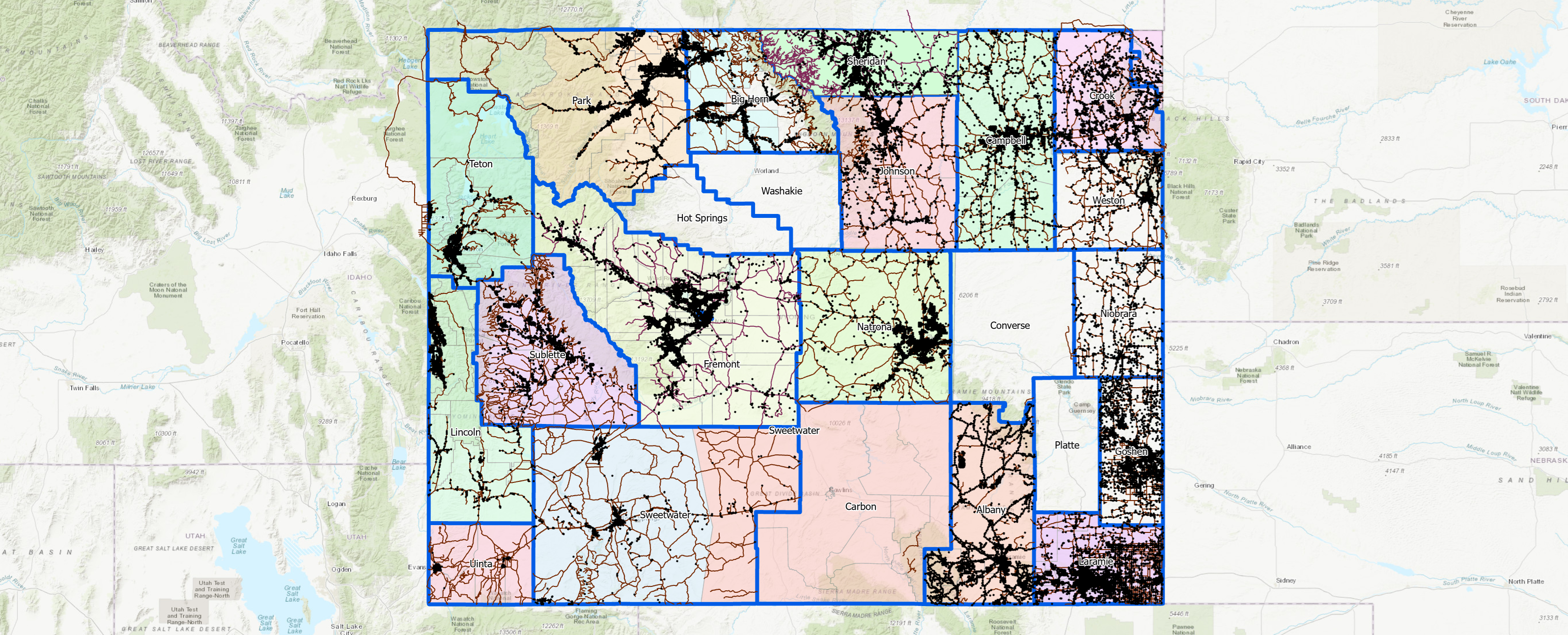
- PSAP Boundaries
- Submitted Data
- Wildland Fire Dispatch
- Data Resources & Validation
- PSAP Financials
- Funding Opportunities
Wyoming's Next Generation 911 Data Migration Portal-Dashboard
Purpose of the Portal-Dashboard
This Portal-Dashboard serves three essential functions for Wyoming's transition to NG911:
- Data Migration Support: Helps local agencies transform their existing GIS data to meet NENA NG911 standards by providing validation tools and clear guidance on required changes.
- Quality Control: Enables agencies to validate their GIS data against NENA standards before submission, ensuring data meets the requirements for NG911 operations.
- Data Exchange Platform: Once local data is validated, serves as the central platform for uploading standardized GIS data to the WyGISC NG911 system.
By using this Portal-Dashboard, local agencies can streamline their transition to NG911-compliant GIS data while ensuring accuracy and consistency across Wyoming's emergency response system.
What is NG911?
In 2021, over 317,000 9-1-1 calls were placed in Wyoming with six counties reporting that 682 texts to
9-1-1 were received. In Wyoming there are 32 Public Safety Answering Points (PSAP) and the Wyoming Highway
Patrol Dispatch Center that serve the citizens of Wyoming.
All areas of the state are served by 9-1-1 or E9-1-1. All control over 9-1-1 operations rests at the local or
county level. Local governments maintain all PSAP equipment and software.
As the transition to Next Generation 9-1-1 (NG9-1-1) moves forward, the State will be responsible for overall
NG9-1-1 coordination, however, control will be retained locally. The coordination will be sustained by working
closely with local representatives on workgroups focused on Geographic Information Systems (GIS) and Technology
relevant to updating the 9-1-1 infrastructure to improve public emergency communication services.
NG9-1-1 is an upgrade of services based on technology upgrades that will enable the public to transmit text,
images, video and data to the PSAP.
Contact Information
For more information, please contact:
Aimee Binning
911 Planning Coordinator
(307) 777-4064
National NG911 Resources
The National Association of State 911 Administrators (NASNA) provides comprehensive information about the nationwide implementation status of Next Generation 911. The interactive map shows the current deployment status across all states, including:
- Overall NG911 deployment progress
- ESInet/NGCS development status
- Originating Service Provider (OSP) migration
- Public Safety Answering Point (PSAP) migration
Source: NASNA NG911 Status
Assessment Data Submitted
Legend
Agencies Each PSAP Dispatches For
PSAPs Boundaries Submitted
Legend
Wildland Fire Dispatch Centers/Zones
Legend
NG911 GIS Data Model Resources
Essential resources to assist local agencies in preparing their GIS data for NG911:
Adopted Wyoming NG911 GIS Data Model Document V1.0
This comprehensive document details the required GIS data structure, attributes, and standards for Wyoming's NG911 system:
View NG911 GIS Data Model V1.0 (PDF)Template Geodatabase
Download this template geodatabase to explore the actual schema implementation. It includes sample data from Kansas to demonstrate proper data structure as well as domain values:
Change Log
-updated postal code field to 5 characters
Download Template Geodatabase Updated on 10-9-25Wyoming DRAFT NG911 GIS Data Model v1.1.0 Working Document
*** This is a DRAFT document for the NG911 GIS Data Model v1.1.0. This will be updated as the model is developed. This is not the adopted model document. ***
View v1.1.0 DRAFT NG911 GIS Data Model (PDF) Draft Date: 10-9-25Validate Data
Why Use This Tool?
Although the NG911 Validator tool was developed for Canadian NG911, it follows the same NENA standards that Wyoming's model is based on. Since both Canadian and U.S. NG911 systems use these universal NENA standards, this tool serves as an excellent resource for preparing your data for NG911 readiness. Once familiar with the NENA standards, you can adjust your data further to meet Wyoming's specific requirements.
By leveraging ArcGIS Online and the NG911 Validator tool, you can efficiently prepare your GIS data for integration into NG911 systems, ensuring compliance with industry best practices.
Step 1: Create an ArcGIS Online Account
- Navigate to ArcGIS Online.
- If you don't already have an account, click Sign Up and choose an account type (public or organizational).
- Follow the prompts to complete the registration process. If you're part of an organization, your administrator may provide access and login credentials.
Step 2: Accessing the NG911 Validator Tool
The NG911 Validator tool is a Canadian ArcGIS Online utility designed to help users validate GIS data against NENA (National Emergency Number Association) standards. While originally developed for Canadian NG911, these NENA standards are the same ones used by the United States NG911 system, making this tool valuable for Wyoming's data validation needs.
** Use the blue NG9-1-1 GIS Validator v2.1.5 button below to navigate to the NG911 validator tool
Step 3: Validating Data Against NENA Standards
The tool primarily validates GIS data for NG911 compliance by checking:
- Road centerlines.
- Address points.
- Emergency service boundaries (fire, law, and EMS).
- PSAP (Public Safety Answering Point) boundaries.
The NG911 Validator reviews your data for consistency, accuracy, and conformance to the NENA standards. While these standards closely align with the Wyoming NG911 GIS Data Model, note that this tool is based solely on the broader NENA standards, not the Wyoming-specific model.
Step 4: Reviewing and Addressing Validation Errors
- After running the validation, the tool generates a report detailing errors, warnings, and information messages for your data.
- Common issues include missing required fields, improper formatting, and geometry errors.
- Use the report to correct issues in your GIS dataset, then re-upload to validate again.
Validate Data To NENA Standards
Upload Validated Data to WyGISC NG911 PORTAL (Disabled - Future Functionality)
Note: The following section will be used after local data validation is complete. These tools will allow you to upload and download data from the WyGISC NG911 Portal.
PSAP Financial Dashboard
Revenue vs Expenditure Overview
County Comparison
Yearly Trends
Revenue Distribution
Year-over-Year Change
County Rankings
Revenue vs Expenditure Efficiency
3-Year Moving Average Revenue
Financial Health Dashboard
County Revenue Status Map
Funding/Grant Opportunities
Supporting Your NG911 Transition
We understand that the responsibility and cost of transitioning to NG911-compliant GIS data falls on individual PSAPs. This represents a significant undertaking in terms of both resources and expertise.
To support your agency in this critical transition, this page will be regularly updated with funding opportunities from various sources, including federal grants, state programs, and other financial assistance options that can help offset the costs of data creation, conversion, and maintenance.
We encourage you to check back frequently for the latest funding opportunities that can support your NG911 data initiatives.
Additional Resources
Federal 911 Funding Programs
The National 911 Program maintains comprehensive information about federal grants and financial assistance opportunities available to support improving emergency communications across the country. Visit the Federal 911 Funding Programs page to find:
- • List of Federal Financial Assistance Programs
- • FY 2024 SAFECOM Guidance on Emergency Communications Grants
- • Emergency Communications Financial Assistance Programs
- • Past Grant Program Information